Understanding Little Lake Butte des Morts requires thinking bigger than just the 1,234 acres of water we see. Like Russian nesting dolls, our lake sits within increasingly larger areas that all influence its health. Here’s why each area matters to every property owner, boater, and lake lover.
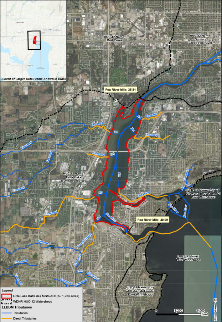
The Lake Area of Interest (1,234 acres)
This is the Little Lake Butte des Morts you know and love—from the Neenah and Menasha dams at Fox River mile 40.09 down to Stroebe Island at mile 35.81. But here’s something you might not know: our management area is actually 30 acres larger than the official WDNR boundary.
Why the difference? Our technical consultants at GEI included the backwater areas behind Stroebe Island that the state database missed—areas that community members specifically identified as important. Those extra 0.67 miles of shoreline matter for comprehensive lake management.
What happens here: This is where we see the direct impacts—algae blooms, invasive aquatic plants, water level fluctuations from dam operations, and the day-to-day conditions that affect your recreation and property values.
The Watershed Area of Interest (44,280 acres – 69 square miles)
Think of this as Little Lake Butte des Morts’ “drainage neighborhood”—all the land where rainwater eventually flows into our lake. This includes two key areas:
Little Lake Butte des Morts HUC 12 Subwatershed (44 square miles)
This contains approximately 100 waterway features, including eight tributaries that drain directly into our lake. The big concern here is Neenah Slough—4.5 miles of “Poor/Impaired” waterway that carries agricultural and residential runoff straight into the lake.
Mud Creek HUC 12 Subwatershed (26 square miles)
Here’s the surprising part: Mud Creek doesn’t actually drain into Little Lake Butte des Morts. So why do we care about these 26 square miles?
Habitat connectivity. Fish, wildlife, and water quality don’t respect watershed boundaries. Mud Creek flows parallel to our lake’s northern edge, and what happens there affects the broader ecosystem we share. Plus, there are proven collaboration opportunities—Outagamie County and Fox Valley Technical College have already shown interest in restoration work in this area.
The Fox Basin – Our 6,567 Square Mile Neighborhood
This massive area—covering much of central and eastern Wisconsin—ultimately drains into our lake through Lake Winnebago. Here’s the chain of connection:
Wolf Subbasin (3,726 sq mi) → Upper Fox Subbasin (1,620 sq mi) → Lake Winnebago Subbasin (572 sq mi) → Little Lake Butte des Morts
Why this massive area affects our lake:
- Nutrient pollution from agriculture and development upstream
- Sediment loading that clouds our water and fills in shallow areas
- Regional water management decisions that affect Lake Winnebago levels and, consequently, our levels
The good news? Significant restoration efforts are already happening throughout the Fox Basin. Our management strategy includes connecting with these regional initiatives to maximize the impact of every conservation dollar spent.
What This Means for Lake Management
This nested approach gives us three different scales for action:
Lake Level (1,234 acres): Direct interventions like aquatic plant harvesting, shoreline restoration, and access improvements.
Watershed Level (44,280 acres): Collaborations with landowners along Neenah Slough and Mud Creek for rain gardens, buffer strips, and agricultural best practices.
Basin Level (6,567 square miles): Coordination with regional efforts, policy advocacy, and grant applications that leverage our local work with broader conservation initiatives.
Understanding these three nested areas helps explain why comprehensive lake management takes time, requires collaboration, and offers opportunities for every stakeholder—from lakefront property owners to businesses in the broader watershed—to make a meaningful difference.
Next up: Learn about the specific tributary conditions and what you can do to help in your area.